A light magnitude 3.9 earthquake was recorded 240 kilometers west of Longyearbyen, Svalbard, on Wednesday, May 15, 2024, at 01:54 pm GMT, according to Volcano Discovery. The tremor, which struck in the remote Arctic region of Svalbard and Jan Mayen, was felt by few and caused no reported damage. Seismologists continue to monitor the area, known for its unique geological activity and proximity to volcanic formations.
Earthquake Measuring 3.9 Magnitude Strikes Off West Coast of Longyearbyen Svalbard
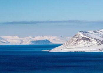
A magnitude 3.9 earthquake shook a remote area approximately 240 kilometers west of Longyearbyen, Svalbard, on the afternoon of May 15, 2024, at 13:54 GMT. The seismic event, recorded by monitoring stations in the Arctic archipelago, remained relatively shallow, occurring at a depth of around 10 kilometers beneath the ocean floor. Despite its moderate intensity, no damage or casualties have been reported, and the quake was primarily felt by monitoring equipment and scientific installations in the region. Such seismic activity is not uncommon here, considering the complex tectonic setting near the Mid-Atlantic Ridge and the Norwegian-Greenland Sea plate boundary.
Authorities and researchers continue to monitor aftershocks and related geological activity, focusing on understanding the underlying causes linked to tectonic plate movements. Key details from the earthquake’s preliminary report include:
- Location: 240 km west of Longyearbyen, Svalbard
- Magnitude: 3.9
- Depth: 10 km
- Date & Time: May 15, 2024, 13:54 GMT
| Parameter | Details |
|---|---|
| Coordinates | ~78.0°N, 10.5°E |
| Seismic Belt | Arctic Mid-Atlantic Ridge |
| Potential Hazards | Minimal |
Seismic Activity in Svalbard Region Raises Questions About Volcanic and Tectonic Risks
A magnitude 3.9 earthquake struck approximately 240 km west of Longyearbyen, Svalbard, on Wednesday, May 15, 2024, at 01:54 pm GMT. This event, though moderate in strength, has intensified scientific interest in the region’s underlying geologic dynamics. Svalbard’s position along the Eurasian and North American tectonic plate boundary makes it a remarkable area for studying both tectonic movements and potential volcanic activity. Recent seismic swarms hint at active crustal adjustments, raising questions about previously underestimated volcanic risks in this Arctic environment.
Experts are closely monitoring a range of seismic parameters to better understand these phenomena. Key considerations include:
- Frequency of aftershocks: Tracking smaller quakes following the main event to assess stress redistribution.
- Depth and focal mechanisms: To distinguish between tectonic fault slips and magmatic intrusions.
- Geothermal anomalies: Potential indicators of rising magma or hydrothermal activity beneath the seafloor.
These data points not only clarify immediate risk levels but also help refine hazard models for local communities and maritime routes in the Arctic. Authorities emphasize continued vigilance, citing the importance of comprehensive seismic networks in this remote but geologically active region.
| Parameter | Current Status | Potential Implication |
|---|---|---|
| Magnitude | 3.9 | Moderate earthquake; potential for aftershocks |
| Depth | ~10 km | Crustal origin; tectonic or volcanic? |
| Seismic Swarm Activity | Increasing | Possible magma movement or fault adjustment |
| Monitoring Status | Enhanced | Improved tracking and early warning |
Authorities Urge Residents and Visitors to Follow Safety Protocols and Stay Informed on Aftershocks
Local authorities emphasize the importance of remaining vigilant following the recent magnitude 3.9 earthquake near Svalbard. Residents and visitors are urged to adhere strictly to established safety protocols to minimize risk from potential aftershocks. Experts remind the public to secure heavy furniture, prepare emergency supplies, and avoid unnecessary travel in affected zones until stability is confirmed.
Staying updated through official channels is crucial as aftershocks may continue to occur in the coming days. The following precautions are recommended:
- Monitor official alerts via government and geological survey websites.
- Maintain communication with family members and neighbors.
- Inspect buildings for structural damage before re-entering.
- Have a clear evacuation plan ready in case of stronger tremors.
| Recommended Items | Details |
|---|---|
| Emergency Kit | Water, food, flashlight, batteries, first aid |
| Communication Tools | Charged mobile phone, portable charger, whistle |
| Safe Zones | Pre-identified outdoor areas clear of hazards |
Final Thoughts
The light magnitude 3.9 earthquake 240 kilometers west of Longyearbyen, Svalbard, serves as a reminder of the region’s ongoing seismic activity linked to its unique geological setting. Although no damage or injuries have been reported, monitoring efforts continue to ensure early detection of any potential hazards. Authorities and scientists alike emphasize the importance of staying informed as Svalbard and the surrounding areas remain under close observation for future seismic or volcanic events.