The European Space Agency (ESA) has successfully launched the Hellenic Fire System satellites, marking a significant advancement in Greece’s ability to monitor and respond to wildfires. Designed to provide real-time data and enhance early warning capabilities, these state-of-the-art satellites will strengthen the country’s environmental protection efforts amid increasing climate challenges. The deployment of the Hellenic Fire System underscores Europe’s commitment to leveraging space technology for disaster management and safeguarding communities.
Hellenic Fire System Satellites Boost Greece’s Wildfire Detection Capabilities
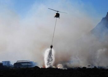
The latest deployment of satellites dedicated to monitoring Greece’s forests marks a significant advance in managing and mitigating wildfire risks. Equipped with cutting-edge sensors and real-time data transmission capabilities, these spacecraft provide unprecedented early warning signals to firefighting authorities, enabling rapid interventions. This technological leap comes as wildfires have intensified due to climate change, threatening ecosystems, wildlife, and communities across the region.
Key features of this space-based fire detection system include:
- Continuous surveillance over vulnerable forest areas, day and night.
- High-resolution thermal imaging that identifies hotspots before fires spread.
- Swift data relay to ground control centers, shortening response times.
| Feature | Benefit | Impact |
|---|---|---|
| Advanced Infrared Sensors | Detects heat anomalies | Early fire identification |
| Geospatial Mapping | Accurate location tracking | Targeted firefighting efforts |
| Real-Time Alerts | Immediate notification | Faster mobilization of resources |
European Space Agency Collaboration Enhances Real-Time Monitoring and Data Accuracy
The collaboration between the Hellenic Fire System and the European Space Agency (ESA) marks a significant leap forward in Greece’s ability to combat and manage forest fires. Leveraging ESA’s advanced satellite technology, the newly launched satellites provide unprecedented real-time data, enabling rapid response teams to detect and track wildfires with increased precision. This partnership channels sophisticated earth observation tools that improve data accuracy through multi-spectral imaging and continuous monitoring, empowering authorities to anticipate fire spread and deploy resources more effectively.
Integration of the ESA’s satellite data has also led to enhanced predictive analytics, benefiting emergency management operations across Greece. Key features of this collaboration include:
- High-resolution thermal imaging for early fire detection
- Real-time hotspot alerts to minimize response times
- Comprehensive environmental impact reports compiled automatically
| Feature | Benefit | Impact |
|---|---|---|
| Satellite Thermal Sensors | Early wildfire detection | Reduced damage to vegetation |
| Multispectral Imaging | Improved smoke and fire analysis | Enhanced firefighter safety |
| Continuous Data Transmission | Real-time monitoring | Faster emergency response |
Recommendations for Integrating Satellite Data with Ground Response Teams to Maximize Impact
Effective integration of satellite data with ground response teams hinges on establishing clear communication protocols. Prioritizing real-time data sharing ensures that fire crews receive timely alerts, enabling swift decision-making on the ground. Satellite imagery should be translated into actionable visuals and summaries tailored to the operational language of firefighters and emergency coordinators. Embedding dedicated liaison officers who can interpret satellite analytics into daily briefings enhances situational awareness and reduces the risk of misinterpretation during critical incidents.
Further, leveraging technology platforms equipped with intuitive dashboards helps synchronize satellite inputs with field reports, creating a unified operational picture. Essential recommendations include:
- Deploying mobile applications that deliver tailored satellite alerts directly to team leaders
- Training personnel in interpreting satellite-derived thermal and smoke signatures
- Regularly updating protocols based on satellite data accuracy and fire behavior patterns
- Integrating AI-driven predictive models with live satellite feeds to forecast fire spread
| Integration Aspect | Best Practice | Impact Metric |
|---|---|---|
| Data Transmission | Secure, High-Speed Networks | 30% faster alert dissemination |
| Team Training | Biannual Satellite Data Workshops | 40% increase in data utilization |
| Operational Coordination | Integrated Command Center Platforms | |————————|———————————–|————————————| |